Hiking with Shawn’s
Trail Guide Series:
Big H
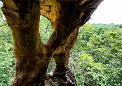
Big H or H-Rock is a natural window/arch feature located in Garden of the Gods Wilderness Area in the Shawnee National Forest. There is a nice 6.3-mile loop (650-foot elevation gain) from the main Observation Trail Day-Use parking area. This trail is designated for horseback riders and hikers so please share the trail and practice equestrian safety while hiking. Remember, a Wilderness Area is rugged, remote and can be difficult to hike – it is important to practice safe hiking practices while enjoying this area. I hope you enjoy my guide to hiking to Big H or also sometimes called, H-Rock.
Area Directions and Trail Information
Check out this map for general points of interest within the area where Big H is located.
To get to Big H from Harrisburg, take Route-145 south to Route-34 (turn left or east). Continue on Route-34 for 9.4-miles until you reach Karbers Ridge Road (turn left or east). Continue on Karbers Ridge Road for 2.8-miles until you reach Shawnee Forest Road (turn left or north/Garden of the Gods Outpost will be on your right as you pass the side of it). Continue on Shawnee Forest Road for 1.3-miles until you reach Garden of the Gods Road (turn left or west). Continue driving 1.3-miles until you reach the Observation Trail parking lot.
All roads leading to the parking lot are paved and in good condition but are windy and hilly in many spots. In the winter, these roads may not be as treated as other roads so please use caution. From Harrisburg to the parking lot, it will be about 20-miles.
Use the Observation Trail parking lot for day hiking. You can park at the Backpackers Parking Lot (parking area right before you go up the hill to the Observation Trail parking lot) for overnight parking and overnight hiking. You cannot park overnight in the Observation Trail parking lot – doing so may get your vehicle towed. There is a fee-based campground (Pharaoh Campground) to the east of the main Observation Trail parking lot. It is a first come, first serve campground.
To access the trail, I recommend using Avenza for your smartphone using the River to River Trail Bundle which both app and the bundle are free. See my Strava Tract Here to see my hiking trip to the Big H.
From the Observation Trail parking lot, walk past the boulders blocking to roadway on the northwest side of the parking lot. The horse high lines are also over in that area. Continue down the gravel path, passing the sign for Anvil Rock Trailhead. This is trail 108K. I recommend taking Trail 108E for better views as it is a hiker only trail with quite a few scenic overlooks, Anvil Rock, the starry night banding and more features. Continue until you get to Trail 001A and turn left onto it. Continue hiking it until you turn left to stay onto Trail 001A. Shortly after you turn left, you’ll want to keep on eye on your left up towards the top of the bluffage. You’ll see Big H when it becomes visible. But this is the GPS coordinates just in case you need them (GPS: 37.60689, -88.39351). There is a trail up to the Big H. The Big H is up at the top of the bluff so you need to be looking up.
PLEASE USE CAUTION AND PUR SAFETY BEFORE ALL ELSE WHEN HIKING AROUND BIG H! In order to access the top of Big H, you will have to climb the bluffage. There isn’t a whole lot of room to climb it and if you fall, serious injury or even death will likely be the outcome. Use common sense here and leave with good memories not bad injuries.
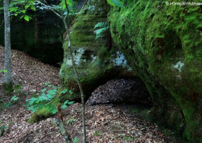
As a bonus, check out Elephant Arch and Cave. Michelle and I are the ones who found this as far as I know. It looks like an elephant at a certain angle. It isn’t very far from Big H and we overnight camped along the bluffage line by it which is a very nice camping spot and apparently a whippoorwill hangout area, LOL. The GPS Coordinates to Elephant Arch and Cave is 37.60677, -88.39252.
Continue hiking on Trail 001A until you can turn left onto Trail 108C. Take it until you turn right on the hiker only Trail108D. This will take you to Trail 108E where you turn right and continue to Trail 108K which is where started out on that takes you to the Observation Trail parking area.
This loop is about 4.2-miles with a little bit more than 650-foot elevation. It is rugged and cell phone signal is very spotty!
Area Sights and Points of Interest
If you follow the hiking route that I have explained above, let me explain what you will be seeing along the route for you visualize now so that you know it when you see it.
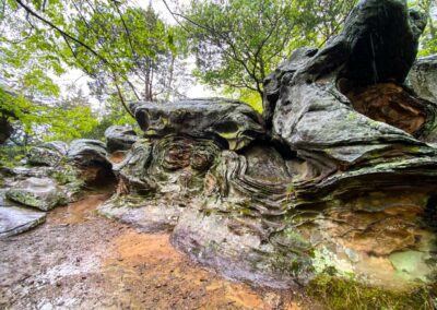
Taking Trail 108E will led you to some cool bluffage with three main features. To your left will be Anvil Rock, a mushroom-like rock shaped like an anvil. Then you the rock formation nicknamed “Starry Night” which is banding that mimic the famous painting with that same name. Between Starry Night and Anvil Rock is an almost arch of sorts that you can walk under. I walk under it every time and it feels like it is getting shorter, or I am getting taller, LOL.
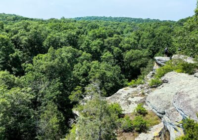
Continuing down the hiker-only trail, you will come to several different scenic overlooks where you can see the whole wilderness area before your eyes. These areas are always very less travelled and enjoyable during all seasons. Just please be careful during wet and wintry seasons as these bluffage areas get slick.
As you make your way down onto 001A, you will start to notice some nice scenic creeks and even more bluffage. There are neat rock formations, natural cave shelters and high bluffage to enjoy along the way to the Big H.
Once you get to the Big H, it will look like just that – A BIG H! It kind of looks like an actual legit window which makes it the perfect natural window. There is a trail up to it and it is possible to climb up and stand next to it. But please, please use caution as your fall hazard will increase. It is a high enough drop that it could kill you so keep that in mind.
Following the bluffage line past Big H will take you to a nice campsite (fire ring and clearing under the shelter) where we once camped a few years ago. Michelle tells me it was the first time a guy has ever cooked her a meal – I cooked Mountain House Teriyaki Chicken (freeze dried meal) with my pocket rocket stove, LOL, but it was delicious! Continue around the bluffage line to discover what we started calling, Elephant Arch and Cave. You’ll understand when you see it. It is a fun rock formation, we think!
As you continue to finish the loop, enjoy more bluffage, scenic creeks and interesting junctions. Once you’re back at the top, finish the day with a nice relaxing easy hike along the Observation Trail which is always a treat!
Area Lodging, Dining, Shopping and Recreation
For other outdoor recreation in this area, check out Garden of the Gods Observation Trail and High Knob Hiker Only Trail. You can also hike at Rim Rock.
Camping is available at Pharaoh Campground next to Garden of the Gods Observation Trail or at Pounds Hollow Campground and Beach. Cabin options are available at Rim Rock’s Dogwood Cabins, Shawnee Forest Cabins and Timber Ridge Treehouses and Cabins. Equestrian camping is available at High Knob Campground, Double M Campground and Camp Cadiz. Wild and dispersed camping can occur within Garden of the Gods Wilderness Area.
For dining options close by, we recommend Cave-in-Rock State Park Lodge in Cave-in-Rock. If you like pizza, be sure to check out Mackie’s Pizza in Harrisburg. The Gap bar and grill is known to have excellent bar food and cold beverages – please drink responsibly! Garden of the Gods Outpost sells ice cream, hot food, some groceries, camping gear, Shawnee merch, Bigfoot swag and maps. Harbison’s General Store also sells a variety of food and other items and is the last place to get gas in the area.
Area Rules and Important Safety Information
Please ensure that you follow all Wilderness Area rules and regulations for the Shawnee National Forest.
Most of the trails for this loop are shared between hikers and horseback riders. Please yield and speak calmly to horseback riders so that their animal knows you are not a threat.
Venomous snakes, poison ivy, ticks and mosquitoes occur in this area.
The number one cause of serious injury and death in this area are from falls. Warning: Fatal falls have occurred in this area – please use caution!
Cell phone signal is little to none in this area. Please inform someone where you are going before you visit and try to hike with a friend if you can. Emergency response may take several hours and most responders in this area are volunteer.
Remember to practice Leave No Trace, pack out what you pack in and Recreate Responsibly so that everyone can have a chance to enjoy our National Forest like anyone else.
To gain more information or find hiking buddies, we encourage you to join our free 15,000+ member hiking group on Facebook at, Southern Illinois Hiking & Outdoor Recreation.
Watch the videos for this trail!
Below is a recent video that we filmed while enjoying this area.
One last thing!
Filming the videos, taking the photos, editing everything and writing this article takes time and it’s all provided for free. Consider making a small monthly contribution to Hiking with Shawn by becoming an official Patreon supporter on Hiking with Shawn! You can also support us by purchasing official merch from the Hiking with Shawn online store. Lastly, please share this article and our videos and follow us on YouTube, Facebook, Twitter, Instagram and Tumbler for more free guides, videos, photos, contests and more!
Thanks for checking out this guide and please share it with others if you’d like to see more of them made!
Shawn J. Gossman
Host
Shawn is the founder and host of the YouTube Channel, Hiking with Shawn as well as Hiking with Shawn LLC. Shawn hikes, backpacks and visits various forested areas in the Shawnee National Forest, local state parks and other areas promoting outdoor recreational activities to obtain video to show to locals and non-locals alike. Please support Shawn’s efforts by sharing this post and leaving a comment below.

