Cache River State Natural Area Guide
Visitors can enjoy miles upon miles of hiking, biking, and nature trails. The Cache has some of the area’s best hunting and fishing spots. The beauty of the Cache is what draws most people to it. It gives you a glimpse of the area long before people settled in the region.
This guide will detail all the information you need about the Cache River State Natural Area. The Illinois Department of Natural Resources (IDNR) manages the area, and they provide additional information on their website and the Wetlands Center.
Now let’s look at what activities you’ll enjoy when visiting Cache River State Natural Area.
Jump to a section:
- About the Cache River
- Directions to the Cache River
- Recreation Opportunities
- Safety Information
- Stuff to do near the Cache River
About the Cache River State Natural Area
The Cache River State Natural Area is an Illinois state natural area maintained by the Illinois Department of Natural Resources. A portion of the Cache River goes into Cypress Creek National Wildlife Refuge and is managed by the US Fish and Wildlife Refuge (FWR). The Cache River is nestled between many areas around the Shawnee National Forest. It goes through multiple communities, making Southern Illinois a unique place to live, work, and visit.
There are three district management units within the Cache River State Natural Area. These are Little Black Slough, Lower Cache River Swamps, and Glass Hill. The Little Black Slough surrounds the Upper Cache River, where many favored trails, such as Heron Pond and Wildcat Bluff, can be found. The Lower Cache River is comprised of bottomlands and floodplains and is favored by many canoeing and kayaking enthusiasts in the area. Glass Hill is an isolated knob located near Cypress, Illinois. It provides a hiking and nature viewing experience around it.
History of the Cache River
More than a 1,000 years ago, many of the cypress trees within the Cache River State Natural Area today were just saplings. When Christopher Columbus landed in the western hemisphere, these saplings were already ancient cypress trees. A natural swamp had always been formed around the trees by glacier floodwater millions of years ago.
Cache River likely provided food, places of shelter, and water sources for early Native Americans. The region was thick in old-growth trees, grasslands, and pristine water sources. After early pioneer settlers arrived, most of the trees were extracted to create cities, homes, and industry. Massive agriculture was created, but due to the extraction of most of the area’s timber, significant erosion caused most farming operations to fail. Over time families on the farms became very poor.
Around the Great Depression era, many of these natural areas were sold to state and federal government agencies. These agencies created public lands in the form of parks and forest preserves. The Civilian Conservation Corps (CCC) created most of these areas and planted over a million trees nationwide. These once heavily eroded and ugly areas were transformed into the natural areas they once were and then opened to the public for visiting and recreating in.
The Cache River itself is 92 miles in length and stretches through multiple Southern Illinois counties, including Alexander, Johnson, Massac, Pope, Pulaski, and Union.
Efforts to Protect the Cache River
Over time agricultural and drainage modifications threatened the existence of the Cache River. In the 1970s, an organization was formed to help protect the Cache River and its natural resources. The organization was known as Citizen’s Committee to Save the Cache River. It was mainly made up of local residents concerned about losing the ancient natural resources of the waterway.
Many efforts were made and successfully accomplished to protect the Cache. Eventually, further partnerships were created, and public-private protection was established. Land was purchased and protected as preserves, such as Heron Pond. If citizens didn’t get together and protect the Cache, it might not be here today.
Friends of the Cache River Watershed
There is a not-for-profit organization known as Friends of the Cache River Watershed. This organization supports the Cache River in partnership with the Illinois Department of Natural Resources (IDNR) and Cypress Creek National Wildlife Refuge. Friends of the Cache comprises board members who meet monthly to conduct activities that benefit the Cache River.
Some of the Friends’ activities include land acquisition to add to the state and federal protected areas, conservation efforts, education, signage replacement, program coordination, and providing merchandise to promote the Cache River Watershed. You can find and purchase Cache River merchandise at the Wetlands Center in Cypress.
Friends of the Cache River Watershed can’t support the Cache River State Natural Area without the help of its members. The Friends request that you help protect the Cache by becoming a member supporter of the Friends today. The Friends are also always looking for people interested in becoming board members who want to help protect the Cache River.
Directions to Cache River State Natural Area
The Cache River State Natural Area has many different points of access. Reaching these points of access is fairly easy. However, many areas will be difficult to access during wintry weather conditions. In some areas, during flooding conditions, access may be limited. Please ensure you plan and research before you visit to ensure that you can safely arrive at your intended destination within the Cache River area. Access to the Cache River mainly consists of paved and gravel roads. Most vehicles should be able to access these roads during normal conditions.
There are no costs or fees associated with parking at any of the following trailheads, centers, and parking lots. Use is first come, first serve.
Please monitor the official state website for any closures due to weather conditions or public health emergencies.
Barkhausen-Cache River Wetlands Center
The Barkhausen-Cache River Wetlands Center is the official Visitor Center for the Cache River State Natural Area.
To reach the Wetlands Center from Marion, Illinois – Take IL-37 south for 30 miles. About 4 miles south of Cypress is the Wetlands Center. It will be on your left-hand side.
To reach the Wetlands Center from Paducah, Kentucky – Take I-24 over the Ohio River and into Illinois. Take Exit 37 (Metropolis/Brookport) and turn left on US-45. Drive 25 miles to IL-169 West and turn left on IL-169 West. Drive to IL-37 and turn right. After you cross the Cache River, the Wetlands Center will be on your right.
There is adequate parking available at the Wetlands Center. The center is open Wednesday to Sunday from 9:00 AM to 4:00 PM. During days and hours when it’s closed, the gate will be closed and locked.
You can read the Wetlands Center by phone at 618-657-2064. The address of the Wetlands Center is 8885 State Route 37 South, Cypress, Illinois 62923.
Lower Cache Water Trail
The Lower Cache River Access is where the water trail can be accessed.
To reach the Lower Cache River Access from Marion, Illinois – Take IL-37 south for 30 miles. After passing through Cypress, look for Perks Road. Turn right on Perks Road. Drive just about 2 miles until you see Access Road on your left. Turn left onto Access Road and drive to the end to reach your destination.
To reach the Lower Cache River Access from Paducah, Kentucky – Take I-24 over the Ohio River and into Illinois. Take Exit 37 (Metropolis/Brookport) and turn left on US-45. Drive 25 miles to IL-169 West and turn left on IL-169 West. Drive to IL-37 and turn right. Drive until you see Perks Road on your left. Turn left on Perks Road. Drive just about 2 miles until you see Access Road on your left. Turn left onto Access Road and drive to the end to reach your destination.
There is adequate parking (with trailer parking) available at this location. This area is for day use only.
Tunnel Hill State Trail
The Tunnel Hill State Trail can be accessed from the Wetlands Center directions above. The trail starts at the Wetlands Center.
Please see my Tunnel Hill State Trail guide for other access points of the 55-mile rail trail for cyclists, runners, hikers, and walkers.
Heron Pond and Little Black Slough
Heron Pond and Little Black Slough are Nature Preserve trails in the Cache River State Natural Area.
To reach Heron Pond/Little Black Slough from Marion, Illinois – Take I-57 to I-24 and merge onto I-24. Take I-24 south to Exit 16 (Vienna/Golconda). Turn right on Exit 16 onto IL-146. Drive west on IL-146 to US-45. Take I-24 south to Exit 16 (Vienna/Golconda). Turn right on Exit 16 onto IL-146. Drive west on IL-146 to US-45. And drive until you see Heron Pond Lane on your right (gravel road with an old church on the corner). Turn right onto Heron Pond Lane. Please drive slowly as people live on this road and it is narrow. Drive to the end of the road to reach your destination.
To reach Heron Pond/Little Black Slough from Paducah, Kentucky – Take I-24 north over the Ohio River and into Illinois. Take Exit 37 (Metropolis/Brookport) and turn left on US-45. Take US-45 Belknap Road. Turn left onto Belknap Road and drive until you see Heron Pond Lane on your right (gravel road with an old church on the corner). Turn right onto Heron Pond Lane. Please drive slowly as people live on this road and it is narrow. Drive to the end of the road to reach your destination.
There is adequate parking available (gravel lot) at the trailhead. This area is for day use only.
Wildcat Bluff and Boss Island
Wildcat Bluff and Boss Island are Nature Preserve trails in the Cache River State Natural Area.
To reach Wildcat Bluff/Boss Island from Marion, Illinois – Take IL-37 south for 22 miles to IL-146 east. Turn left onto IL-146 and drive east until you reach Oak Grove Road on your right. Turn right onto Oak Grove Road and drive to Wildcat Bluff Road. Turn right onto Wildcat Bluff Road. Drive to the end of the road to reach your destination.
To reach Wildcat Bluff/Boss Island from Paducah, Kentucky – Take I-24 north over the Ohio River and into Illinois. Take Exit 37 (Metropolis/Brookport) and turn left on US-45. Drive until you see Ballowe Church Road on your right. Turn right onto Ballowe Church Road and drive until you see Hawkins Road on your left. Turn left onto Hawkins Road and drive until you see Wildcat Bluff Road on your left. Turn left onto Wildcat Bluff Road. Drive to the end of the road to reach your destination.
There is adequate parking available (gravel lot) at the trailhead. This area is for day use only.
Marshall Ridge and Tupelo Trail
Marshall Ridge Access and Tupelo Trail are trail access points within the Cache River State Natural Area.
To reach Marshall Ridge/Tupelo Trail from Marion, Illinois – Take I-57 south to I-24 and merge onto I-24. Take I-24 south to Exit 16 (Vienna/Golconda). Turn right on Exit 16 onto IL-146. Drive west on IL-146 to US-45. Turn left onto US-45 and drive to Belknap Road. Turn right onto Belknap Road to W Main Street in Belknap. Turn right onto W Main Street and drive to Sunflower Lane. Turn right onto Sunflower Lane. Drive to and merge onto Gate Across Road and pass the Cache River HQ building. Drive to the end of the road, and you’ll reach your destination.
To reach Marshall Ridge/Tupelo Trail from Paducah, Kentucky – Take I-24 north over the Ohio River and into Illinois. Take Exit 37 (Metropolis/Brookport) and turn left on US-45. Take US-45 Belknap Road. Turn left onto Belknap Road to W Main Street in Belknap. Turn right onto W Main Street and drive to Sunflower Lane. Turn right onto Sunflower Lane. Drive to and merge onto Gate Across Road and pass the Cache River HQ building. Drive to the end of the road, and you’ll reach your destination.
There is adequate parking available (gravel lot) at the trailhead. This area is for day use only.
Big Cypress Access
Big Cypress Access is a trail within the Cache River State Natural Area.
To reach Big Cypress Access from Marion, Illinois – Take IL-37 south for 28 miles until you reach W Eden Road. Turn left on W Eden Road and drive to Porter House Road. Turn right onto Porter House Road. Drive 1 mile, and your destination will be on your left.
To reach Big Cypress Access from Paducah, Kentucky – Take I-24 north over the Ohio River and into Illinois. Take Exit 37 (Metropolis/Brookport) and turn left on US-45. Drive 25 miles to IL-169 West and turn left on IL-169 West. Take IL-169 through Karnak until your reach Urbana Road/Porter House Road on your right. Turn right and drive a little over 1 mile. Your destination will be on your right.
There is adequate parking available (gravel lot) at the trailhead. This area is for day use only.
Section 8 Woods
Section 8 Woods is a trail located within the Cache River State Natural Area.
To reach Section 8 Woods from Marion, Illinois – Take IL-37 south for 30 miles. About 4.5 miles south of Cypress is the Section 8 Woods. It will be on your left-hand side.
To reach Section 8 Woods from Paducah, Kentucky – Take I-24 over the Ohio River and into Illinois. Take Exit 37 (Metropolis/Brookport) and turn left on US-45. Drive 25 miles to IL-169 West and turn left on IL-169 West. Drive to IL-37 and turn right. Before you cross the Cache River, Section 8 Woods will be on your right.
There is enough room for a few cars and a handicapped spot. Parking is parallel only. This is a day-use-only area.
Hunting Access Areas
Numerous gravel parking lots exist around Perks Road (Lower Cache), Belknap Road, US-45, and Porter House Road for access to the Cache River State Natural Area for game harvesting. Many of these parking lots have hunter sign-in boxes installed at them.
Recreation at the Cache River State Natural Area
There are many different recreational opportunities available at Cache River State Natural Area. Most of these activities have no cost or fee associated with them other than licensing needed for fishing and game harvesting. The natural area is for day use only. Some areas may be closed due to weather conditions, public health emergencies, or other reasons. Try to have a Plan B when visiting these recreational areas, just in case.
Hunting and Fishing
Seasonal hunting occurs within the Cache River. Some of the game that’s harvested from the area include deer and turkey. An Illinois hunting license is required. Those who use firearms for hunting must also have a Firearms Owner Identification card or FOID in the State of Illinois. Please see the Illinois Department of Natural Resources (IDNR) Hunter Fact Sheet for more information about hunting in this area.
Fishing is allowed along the Cache River. You must possess a valid Illinois Fishing License to fish.
Hiking, Biking, and Nature Viewing
There are ample opportunities for hiking, biking, and nature viewing around the Cache River. Please note that these areas are for day use only. During firearms hunting season, you are advised not to use these trails as hunters will be in the area. Please see the Directions section above to find directions to these trails.
Hiking Trails
The following hiking trails are for day use only. Camping along these trails is prohibited. These trails are designated for hiking only. Motor vehicles, bicycles, and equestrian use are prohibited. Most of these trails have minor elevation aside from Wildcat Bluff, which does have a tough hill when coming from Boss Island.
Todd-Fink Heron Pond Trail – This is a 1.5-mile (out and back with loop) trail considered the most popular in the Cache River State Natural Area. You’ll see the Cache River, swamplands, and wildlife along this trail. During warmer conditions, it’s not unlikely to see snakes (many of them are venomous cottonmouth). There is a boardwalk over Heron Pond and a large Cherrybark Oak Tree that is a state champion. Heron Pond is a Nature Preserve – please stay on the designated trail to help protect the precious flora and wildlife that thrives in this area. Restrooms (vault) are available. Bike racks are available,
Little Black Slough Trail – This is a 5.5-mile (out and back) trail that can be accessed from its connection to the Heron Pond Trail. On this trail, you’ll see cypress and tupelo swamps, bluffs, and a range of different diverse forests.
Wildcat Bluff Trail System – Wildcat Bluff has a few different trails. The 1-mile Lookout Point Trail (out and back) will take you to a point where you can see an overlook of the Cache River and its floodplains. This is a great trail to take during the fall color season. Another opposite trail direction of Lookout Point follows an old wagon road and will take you to the Cache River. There is a set of concrete pillars that you can use to cross the river. These pillars will be underwater and impossible to cross during high river levels.
Boss Island Trail: This short trail system connects the Cache River crossing from Wildcat Bluff to Little Black Slough. On this trail, you’ll see an old Cabin that hunters once used as its last use. Before hunters, the cabin housed 8 people at one time. There has never been potable water or electricity running to the cabin. Please consider not going into the cabin, as wildlife often roosts within it.
Marshall Ridge Trail: This 2.8-mile (out and back) trail will link to the Heron Pond and Little Black Slough trails from the access point on Gate Across Road in Belknap, just past the HQ building. This trail mainly consists of hiking on a forest road. There are some signs of former settlements along this road. You will need to take this trail to access the Tupelo Trail.
Tupelo Trail: This 2.5-mile (loop) trail can be accessed from the Marshall Ridge Trail. It features excellent views of the swamp as well as some rocky hillsides. This would be a great place to watch for wildlife like bald eagles, egrets, herons, etc.
Lower Cache River Trails: There are two trails at the Lower Cache River Swamp Access. One goes around the swamp, about 2 miles long (out and back). You’ll see the swamp and a forest on one side. The other trail is concrete (good for disabled visitors), less than a third of a mile. It ends at a viewing platform over the Lower Cache Swamp. Restrooms (vault) are available.
Big Cypress Access: This trail is the shortest trail in the Cache River State Natural Area. It is a couple of 100 feet out and back. It leads you to very large and ancient cypress trees. Some of the larger trees are over 1,000 years old. One tree is known as the Poobear Tree for obvious reasons.
Section 8 Woods: The trail consists of a short boardwalk (out and back) of a couple of hundred feet. It’s slightly longer than Big Cypress Access. The boardwalk leads you through a cypress-tupelo swamp. There was a large state champion tree to view at one time, but wind storms a few years back uprooted the tree, and it fell down. It’s now a wildlife habitat. Review the signage at the beginning of the trail to learn more about the area.
Tunnel Hill State Trail: The Tunnel Hill State Trail is a 55-mile rail trail formerly a railroad track. It is the only trail in the Cache River areas where bicycles are allowed. Runners, hikers, and walkers are also welcome. Motor vehicles and equestrians are prohibited. Equestrians do cross the trail where the River to River Trail crosses. Please yield to horses crossing if you see them.
Canoe and Kayak Trail
Canoe and kayak opportunities are available at the Lower Cache River Swamp Access (directions are above). There is a ramp provided.
There are water trails consisting of 3 to 6 miles in length. One of the largest cypress trees can be seen on these water trails. Paddlers should remember that the upper Cache River is almost impossible to use due to severe erosion and many trees down across the river.
The water trails are marked with canoe signs and yellow stripes on trees.
Check out the IDNR Canoe Fact Sheet and the Water Trail Map for more information.
If you need to rent a canoe, you can rent one and a canoe guide from Cache Bayou Outfitters.
Restrooms (vault) are available at the Lower Cache Swamp Access.
Barkhausen-Cache River Wetlands Center
The Barkhausen-Cache River Wetlands Center is a great place to visit for people of all ages. This is one of the best Illinois State Visitor Centers in the region. The workers are very knowledgeable about the area.
There are interpretive rooms in the center and a video room where you can watch the story of the Cache River. This is free to everyone. Wildlife displays (turtles and snakes) are often set up at the Wetlands Center.
The Wetlands Center also sells many Cache River merchandise items, nature books, stuffed critters, and more. Purchasing these items helps the Friends of the Cache River Watershed support the Cache River.
The outside area around the Wetlands Center features walking paths, a boardwalk over a swamp, and native plant garden spots. Enjoy a birding experience at this location. The Tunnel Hill State Trail also has a starting point at the Wetlands Center.
There is adequate parking available at the Wetlands Center. The center is open Wednesday to Sunday from 9:00 AM to 4:00 PM. During days and hours when it’s closed, the gate will be closed and locked.
You can read the Wetlands Center by phone at 618-657-2064. The address of the Wetlands Center is 8885 State Route 37 South, Cypress, Illinois 62923.
Restrooms and drinking water are available at the Wetlands Center.
Special Events and Programs
The Cache River Wetlands Center (noted above) hosts monthly events that are often free and open to the public. These events are typically appropriate for visitors of all ages. These events can be found by visiting the Friends of the Cache River Watershed Events Page or calling the Wetlands Center at 618-657-2064. Some of the events include presentations and outside events such as butterfly tagging.
Cache River Safety Information
There are a few safety concerns that all visitors of the Cache River State Natural Area should be made aware of:
- Venomous snakes occur in the Cache River. These include cottonmouth and copperhead. These snakes are protected under state law on state property.
- The Cave Creek Glade requires a permit for access. Accessing the glade without a permit can result in a fine.
- Stay on all designated trails. Don’t create your own trails or user non-designated user trails.
- Swimming in any water or any part of the Cache River is prohibited.
- The Cache River is for day use only. Camping is not allowed within the state area.
- Ticks are bad here – please take tick-bite preventative measures.
- Due to the swamp environments, mosquitoes and biting flies are typically worse here than in other parts of the region. Use plenty of bug spray.
- Mobile device reception is typically not available within this area.
- During heavy rain events or flooding, many trails and areas around the Cache River will be inaccessible and underwater.
- Never try to cross Cache River down from Wildcat Bluff when the water is over the concrete steppingstone pillars.
- Tell someone where you’re going before you go, try not to hike alone, and ensure you bring plenty of water when visiting the Cache River State Natural Area.
Lodging, Dining, and Sightseeing Around the Area
Plenty of lodging, dining, and sightseeing are around the Cache River State Natural Area.
An Airbnb called Country Schemes B&B is located close to Heron Pond. AdamsRock Cabins are close to the Cache. Camping is available at the Main Brothers’ Campground in Karnak.
Dining is available around the Cache River area. Dine at Las Maria’s for good Mexican food, or have a sandwich from Sawyer’s Subs near Cypress and Karnak. Visit Vienna for many different additional dining options. Wineaux’s near Heron Pond has great wine and dining. Metropolis also has many different great dining establishments to choose from.
While visiting the Cache River State Natural Area, check the many different things to do around the nearby Shawnee National Forest.
Watch the videos for this trail!
Below is a recent video that we filmed while enjoying this area.
Check out the trail gallery!
Enjoy these photos taken around this area!
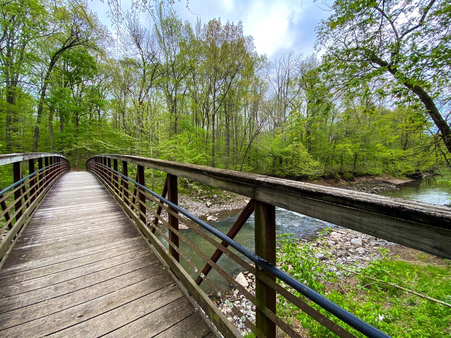
Cache River Bridge
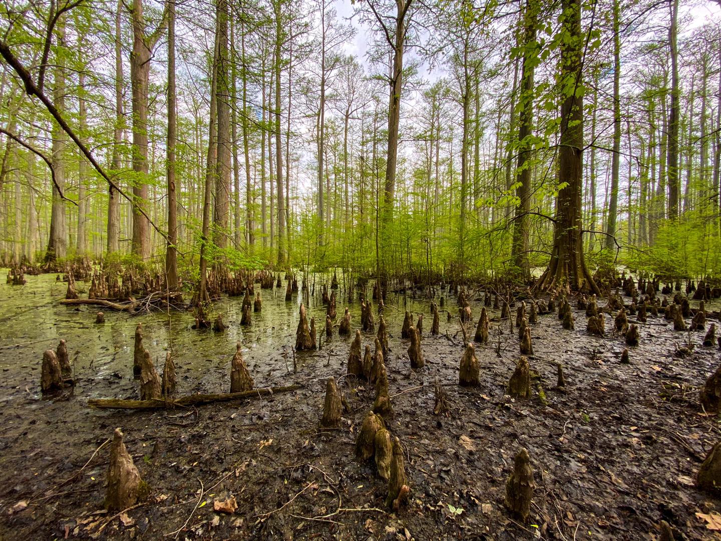
Cypress Knees
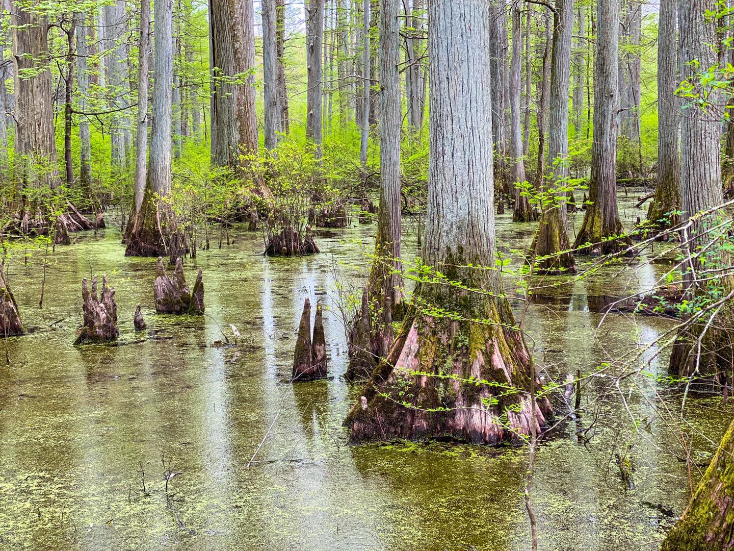
Cypress Swamp
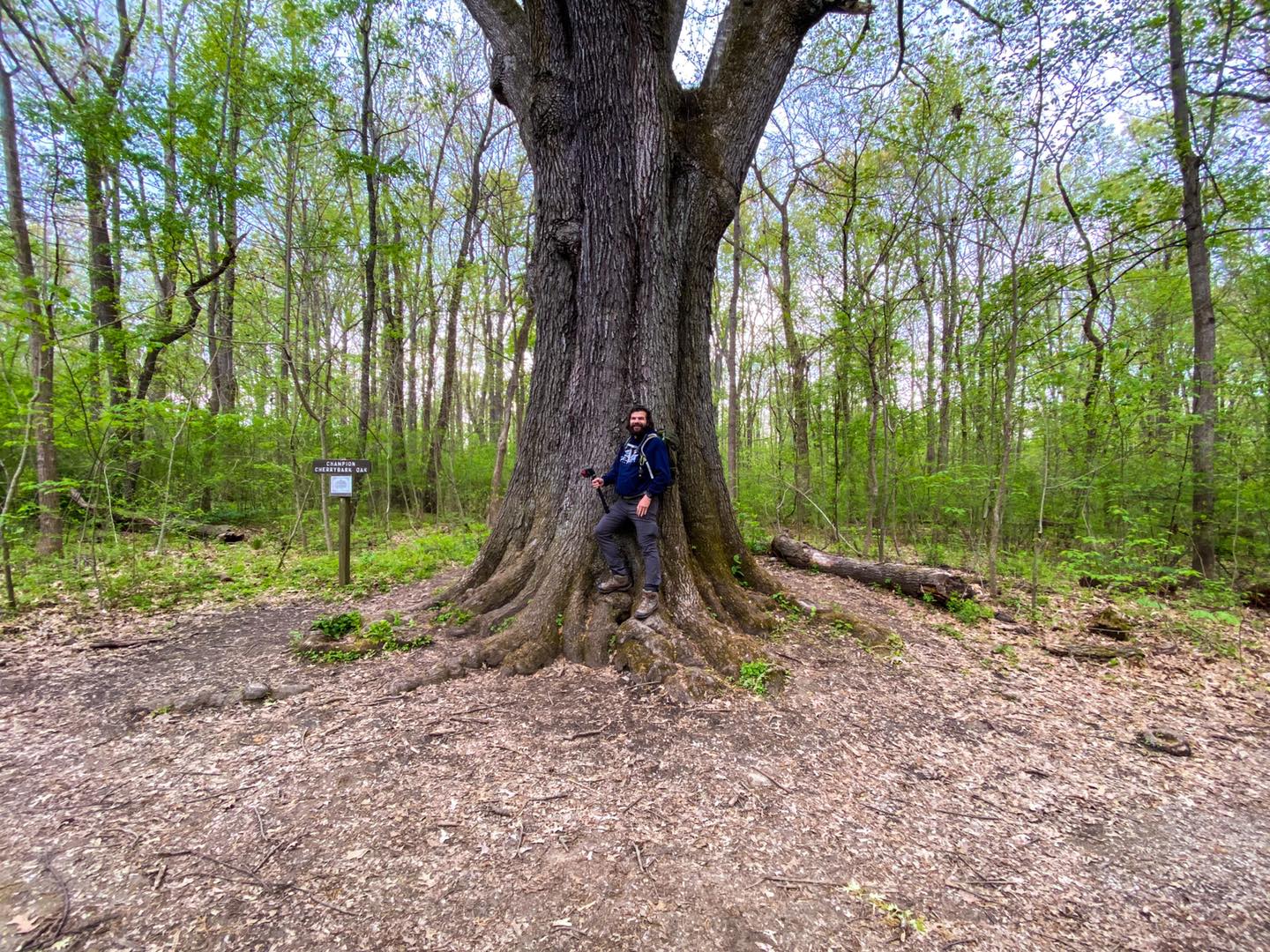
Champion Cherrybark Oak
Please Support Hiking with Shawn
Alrighty folks, I hope you have enjoyed this content. I provide it for free and it takes a while to create. If you would be so kind enough to support my efforts, you can do so by sharing this post with others, especially on social media. Be sure to subscribe to my YouTube Channel to see my latest videos, shorts and live streams. Follow me on Facebook, Instagram, Twitter and TikTok for unique content that you will only find on those pages. You might also join my Southern Illinois Hiking & Outdoor Resources Group on Facebook, too!
You can also support me by becoming a Patreon Supporter for as little as $3/month and you can cancel anytime (no contracts or catches). Patreons get access to extra features, exclusive articles, sticker packs, gifts and more. Consider buying official Hiking with Shawn Merchandise as another way to support me. I spend a lot of money on Hiking with Shawn and because of extremely high public land permit fees, I make very little money in return so everything helps.
Thanks again for checking out another one of my articles and until next time, I’ll see you on the trail!

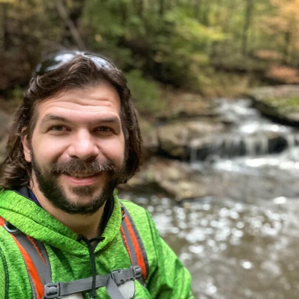
Shawn Gossman
Founder, Hiking with Shawn
Howdy folks! My name is Shawn Gossman and I founded Hiking with Shawn. I’m an avid hiker, cyclist and outdoorsman here in the Shawnee National Forest. I was born and raised in Southern Illinois and never want to leave. Click here to learn more about Shawn Gossman