One Horse Gap
Hiking Guide
for the
Shawnee National Forest
One Horse Gap is a beautiful area located in the Shawnee National Forest.
There are ample hiking opportunities available at this location. Other great activities in this area include fishing, paddling, horseback riding, hunting, geocaching, and camping. Many gravel forest roads and trails throughout the general area are also often used for recreational driving and bicycling.
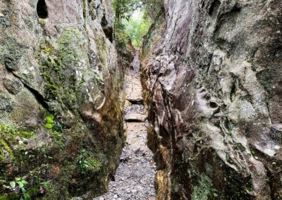
The main feature and reason behind its name, One Horse Gap, is the natural gap between bluffs large enough to fit one horseback rider through it at a time. Aside from the gap, numerous scenic overlooks include Rocky Top as waterfalls during the wet seasons.
Hunters and regular campers often use several primitive campsite locations around the area. Camping is free. There are no available electricity or water sources.
One Horse Gap is a great location to enjoy hiking and other outdoor recreation activities, and you could easily spend the whole day there.
How To Get To One Horse Gap
The following directions use Google Map links to get you to various parking locations within this recreational area.
Benham Hill Trailhead (Large Trailhead for multiple horse trailers and vehicles)
Check out this Google Maps link to get to this area from Harrisburg, Illinois, in about half an hour. Once you get past the blacktop and onto the gravel roads passed Herod, be careful of potholes. Our gravel roads have plenty of large potholes. Use common sense and drive slowly around them, and you will be fine. Dutton Chapel Road is mainly dirt and rock but can be tricky if the road is wet. Please tread lightly on these roads as people live on them and have to use them daily. Tearing them up with jeeps and trucks is irresponsible to the people who live out there. Benham Hill Road (FSR 186) often has large, eroded spots that will tear your vehicle up if you go fast over them. Again, take it slow, and you’ll be fine. The parking lot on Benham Hill Road will be to your right (there is Forest Service Sign), and you can’t miss it. I often call it the Walmart Parking Lot of the Shawnee National Forest because it’s enormous.
End of Benham Hill Road (Small parking area with capacity for a few vehicles)
The end of the road has limited parking and would not be suitable for a horse trailer as it would be hard to get turned around. Using the directions above for the Benham Hill Trailhead, drive past the trailhead until the road ends at trails. The road is long and seems like you’re driving forever at times.
Easy Access to Rocky Top Scenic Overlook
This is where you need a working GPS and knowledge of how to use it. Using the directions above, drive past the big parking lot on Benham Hill Road (FSR 186). Drive to the GPS coordinate of 37.52721, -88.45691. You will see a trail to your right which will take you to Rocky Top within a few minutes of hiking. It isn’t even a mile out and back. Parking is on the side of the road. Give plenty of room for other vehicles to pass. The coordinates of Rocky Top are 37.52648, -88.45371.
Easy Access to One Horse Gap
Drive past the big parking lot on Benham Hill Road (FSR 186) and to the GPS coordinates of 37.52158, -88.46306. You will see a trail on your right. This will take you to the gap located at coordinates 37.51811, -88.45959. This trail is quicker than hiking from Benham Hill trailhead if you desire a shorter hike. Park on the side of the road while giving plenty of room for other vehicles to pass.
One Horse Gap Lake
Check out this Google Maps link for a 45-minute drive from Harrisburg, Illinois, to the actual lake. The road to the lake is gravel and contains potholes here and there – so drive slowly and use caution. There is limited parking around the lake. Please be courteous to trucks carrying boat trailers to access the lake.
How to Access Trails at One Horse Gap
Below are the many different trails and activities that can be enjoyed around this area of the Shawnee National Forest.
Benham Hill to One Horse Gap Loop (5.6-miles, Loop)
This loop trail starts from and ends at the large parking lot trailhead on Benham Hill Road. It will take you to One Horse Gap and loop back using the actual Forest Service Road 186, Benham Hill Road. This is an excellent hike with fair elevation but would be considered moderately rugged. There are rolling hills, creek crossings, and rocky surfaces. Hikers share the trail with horseback riders. Mountain bikers are also known for using these trails.
Hikers will see multiple bluff lines, natural shelters, scenic overlooks, and the gap along this route.
Maps and Files: All Trails Map | Avenza Map | Forest Service Map
One Horse Gap Lake Trail (2-3 miles, Loop)
A friendly hiker/horseback trail goes around the One Horse Gap Lake. Hiking this trail will give you beautiful views of the lake and a diverse trek through non-native pine and native-hardwood forests. The trail number used for this trail is 172. While blazes may not be present, the trail should be easy to follow. There could be stinging nettle around the lake shore portions during the summer months, so be careful. To get to this trail, use the directions to the lake above. You can park at the lake – be mindful of people with boat trailers that need to access the ramp.
Maps and Files: Forest Service Map
One Horse Gap Lake
The lake itself is a 26-acre artificial lake. The Forest Service quotes on their website that it “is a favorite during hot summer days for a cool dip,” which appears to say that swimming could be allowed in the lake. There are no beaches, though. I’ve observed people swimming from the boat ramp at the lake. If you decide to swim, you do so at your own risk. Cell phone signals may not be available in an emergency.
Boats with electric motors only may use the lake. An unimproved boat ramp (gravel) is provided at the lake directions mentioned above.
There is a six-daily creel limit for largemouth bass and catfish. Largemouth bass has a 15 minimum length restriction.
Primitive camping is available around the lake entrance and shore. Camping is free. There are no electric or water hookups.
Safety Advice for One Horse Gap Users
Hikers, horseback riders, and mountain bikers may sometimes use trails. Please share the trail and always yield to horseback riders as their animal is much harder to stop and control than your feet or bike tires.
Venomous copperhead and timber rattlesnakes occur in this area. It is illegal to harass, harm, or kill these snakes. You’re encouraged to report violators to US Forest Service Law Enforcement at 618-201-3364. You can remain anonymous.
During firearms hunting season, this area is widely used by hunters. Unless you’re hunting, I highly recommend you avoid this area. Hunters only get a few weeks a year to do their thing, and they bring a lot of money to the site – we should give them plenty of space during this time. At least for the sake of your safety.
Dangerous conditions exist in this area. Please watch your step and be careful around the edges of cliffs and bluffs.
There are no lifeguards present at the lake.
A cell phone signal may not be available in an emergency.
If you have an emergency – call 911.
Other Things To Do Around One Horse Gap
There are other hiking and outdoor recreation opportunities around this area. Lusk Creek Wilderness is nearby and features multiple hiking and equestrian trails. Garden of the Gods Wilderness is close to this area and can be accessed from Herod.
For nearby lodging, try Willowbrook Cabins which are very close to the Lusk Creek Access, where you can launch kayaks and canoes into the Lusk Creek.
For dining options, Harbison’s Country Store has delicious food choices and has the only gas around the area. The Gap Bar and Grill is another good source for dining and alcoholic drinks. Please drink responsibly.
Watch the videos for this trail!
Below is a recent video that we filmed while enjoying this area.
Please Support Hiking with Shawn
Alrighty folks, I hope you have enjoyed this content. I provide it for free and it takes a while to create. If you would be so kind enough to support my efforts, you can do so by sharing this post with others, especially on social media. Be sure to subscribe to my YouTube Channel to see my latest videos, shorts and live streams. Follow me on Facebook, Instagram, Twitter and TikTok for unique content that you will only find on those pages. You might also join my Southern Illinois Hiking & Outdoor Resources Group on Facebook, too!
You can also support me by becoming a Patreon Supporter for as little as $3/month and you can cancel anytime (no contracts or catches). Patreons get access to extra features, exclusive articles, sticker packs, gifts and more. Consider buying official Hiking with Shawn Merchandise as another way to support me. I spend a lot of money on Hiking with Shawn and because of extremely high public land permit fees, I make very little money in return so everything helps.
Thanks again for checking out another one of my articles and until next time, I’ll see you on the trail!
Shawn Gossman
Founder, Hiking with Shawn
Howdy folks! My name is Shawn Gossman and I founded Hiking with Shawn. I’m an avid hiker, cyclist and outdoorsman here in the Shawnee National Forest. I was born and raised in Southern Illinois and never want to leave. I hope you enjoy my website and I encourage you to interact with me!

Trackbacks/Pingbacks