Hiking with Shawn’s
Trail Guide Series:
Packentuck Waterfalls
Packentuck Waterfalls are a series of unofficial trails located in the Shawnee National Forest off Packentuck Road. This area borders private property as well as Camp Ondessonk so a map/app with boundary lines and topography features will be really handy for exploring this area. Please remember to respect private property at all times and drive slowly and carefully down Packentuck Road if you visit as people live on this road. Packentuck Waterfalls are hidden gems of the Shawnee National Forest and you defiantly should put this area on your bucket list and places to visit when wet.
Keep in mind – dangerous conditions exist in this part of the Shawnee National Forest. Please exercise caution when exploring waterfalls. Areas will be extremely slick, and falls can lead to serious injuries to even death. Cell phone signal may not work in this area which will make calling for help a lot more difficult especially if you are unable to move. Always tell someone where you will be hiking before you go and try to hike with a friend. Leave the Shawnee National Forest with good memories, not bad injuries.
Packentuck Waterfalls Area Directions and Trail Information:
Check out this map for more information of where Packentuck Waterfalls and other features are located. Take note of the GPS coordinates before going to the area as cell phone signal will likely not exist.
If driving from Vienna, go north on US-45 from the four way stop near Ned’s Shed. Travel about 12 miles until you reach Ozark Road on your right, turn onto Ozark Road. Travel about 2 miles until you see Packentuck Road to your right. Turn onto Packentuck Road and drive .3 of a mile, until the forest is on both sides of your vehicle. You should see a trail to your left. That is your trail. There are no signs or trailhead information – park on the side of the road giving plenty of room for those who live and travel on the road. Blocking road access will likely result in your vehicle being towed at your expense.
Take the trail and stay on it traveling east-southeast until you reach the first waterfall. This is known as Indian Falls. You will also see old settlement sites along the way. Continue on the horse trail system there to visit other waterfalls in the area. The map linked above will give you locations of the waterfalls or you can go to the following coordinates:
- Indian Falls: 37.52954, -88.72660
- Crevice Falls: 37.52194, -88.72691
- Little Cedar Falls: 37.52202, -88.72170
The horse trail system will get you to every waterfall out in that area plus the other features such as the Natural Arch, cascades and older settlement sites. You will have to cross creeks at times, and they may be a few feet deep. The trail’s terrain includes rocky conditions, rolling hills and will often be muddy when wet. The area difficultly would easily be rated as very rugged and difficult. The waterfalls are heavily dependent on rainfall therefore best results will be after a few days of good heavy rainfall.
These waterfalls are on Shawnee National Forest land. This area is bordered by private property belonging to private citizens as well as Camp Ondessonk. Camp Ondessonk requires you to gain official permission to access their land which may not be done when the summer camp is in session.
Please contact Camp Ondessonk for access information – Hiking with Shawn cannot grant you access to this area. Please note that if you access Ondessonk property without their permission, you will be illegally trespassing on private property.
I recommend using a property boundary app such as OnXHunt (not sponsored) to access this area and to avoid trespass.
Packentuck Waterfalls Area Expectations and Points of Interest
When first hiking the trail, within the first few miles, you will come up to signs of the past including foundations, wells (still open and hazardous if you fall into them), daffodils and iris flora, yucca plants, old fencing and barbed wire and even structures that are still partially up. Notice the old roads and huge wolf-trees in the areas of old settlement. Before this area was a National Forest, people once lived there. Imagine living in a place like this with all of the awesome waterfalls and natural features. Please watch your step for existing hazards left behind.
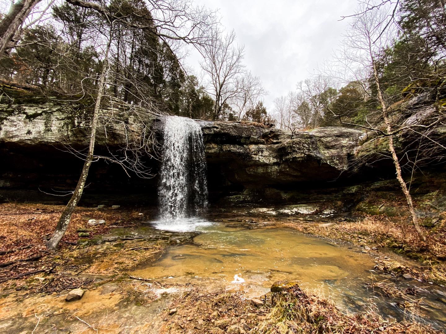
As you continue on, Indian Falls will be your first waterfall if you take the trail clockwise. The coordinates above will come in handy for finding these waterfalls – it may be difficult without GPS navigation as there are other user-trails in the area that lead away from the waterfalls. Indian Falls is amazing, and features are very scenic and beautiful creek down the way from it. Be sure to follow that creek for even more smaller cascade waterfalls and really scenic looking areas.
When you reach Crevice Falls, if it is flowing well, you are going to be amazed. It has to be one of my favorite waterfalls of all times. If on top, facing the edge of the waterfall, you can get down easier (but please use caution) by going to the right of the fall a few feet. You will see the chute that you can take to get down. The creek that Crevice Falls flows into is also just as amazing as the waterfall especially when traveling right of the fall to see the bluffage so close to the creek. You’ll have to cross the creek a few times to follow the bluff line here.
On your way too Little Cedar Falls, be sure to climb up and check out the Natural Arch. It reminds me of one in the Garden of the Gods area nearby to the Golden Circle area. This is an amazing waterfall with all sorts of windows and shelters around it. The top of the fall through the pine grove is also just as amazing.
This area is truly a hidden gem of a place. There is a lot to see here so defiantly start out as early as you can especially if daylight ends earlier.
Packentuck Waterfalls Area Safety, Rules and Other Tips
Chasing waterfalls is an extremely adventurous activity. It can result in you seeing some of the most unique and scenic points within the Shawnee National Forest. And while it is a great activity to take up, you should fully understand the risks associated with chasing waterfalls as well. People in the Shawnee National Forest have been seriously injured and have even died as a result of falling at waterfall sites. Please use extreme caution especially around the tops of waterfall areas. If rock is wet, it is going to be slick and if it’s green and wet, it will be as slick as ice is. It won’t take much to fall. Cell phone signal in this area is not always available so if you fall and you’re alone, you may not get help for a long time. Please keep this in mind and exercise safety and common sense when out chasing waterfalls.
Poison ivy, venomous snakes, unprotected wells, barbed wire and other natural hazards exists in this particular area. Avoid coming into negative contact with these hazards by watching your step, putting safety first and by using common sense.
This area is best explored when the leaves are off the trees such as in late fall, winter and early spring. In the summer months, expect trails to be grown up with a lot of undergrowth.
Please always yield to horseback riders and talk to them in a calm manner so that their horses know you are not a threat. Hikers and mountain bikers MUST always yield to equestrians at all times.
There are no trash services in this area. Please pack out what you pack in and leave the area better than you found it in the first place. Litter only threatens the natural beauty and wildlife habitats of the National Forest. Please report suspicious activities to local law enforcement to be relayed to the US Forest Service.
This area is managed by US Forest Service – Shawnee National Forest, Hidden Springs Ranger District out of Vienna, Illinois.
Other Points of Interest in the Packentuck Waterfalls Area
For other hiking opportunities in this area, check out my guides for Jackson Falls, Burden Falls Wilderness, Bay Creek Wilderness, Trigg Tower and East Trigg to Millstone Lake. Check out Camp Ondessonk for other outdoor opportunities especially for younger children and teenagers. For biking opportunities, see the Tunnel Hill State Trail.
For nearby equestrian information and camping, see Hayes Creek Campground.
For other camping (hiking, bikepacking, RV, etc.), see Hangout Campground, Red Bud Campground and Shawnee Forest Campground. Check out Shawnee Paradise for Airbnb options in the area.
For nearby area dining, I recommend Murphy’s BBQ in Ozark very close to the Packentuck area as well as Shotgun Eddy’s in Eddyville and Ned’s Shed, Family Diner and of course Wildfires Steakhouse all located in Vienna.
Be sure to visit the Shawnee National Forest Hidden Springs Ranger Station in Vienna for official Forest Service information, maps and any questions you may have for Forest Service personnel. Stop by the Vienna Visitor Center for area information and attractions.
Watch the videos for this trail!
Below is a recent video that we filmed while enjoying this area.
Check out the trail gallery!
Enjoy these photos taken around this area!

Old Structure

Indian Falls

Crevice Falls
Little Cedar Falls
One last thing!
Filming the videos, taking the photos, editing everything and writing this article takes time and it’s all provided for free. Consider making a small monthly contribution to Hiking with Shawn by becoming an official Patreon supporter on Hiking with Shawn! You can also support us by purchasing official merch from the Hiking with Shawn online store. Lastly, please share this article and our videos and follow us on YouTube, Facebook, Twitter, Instagram and Tumbler for more free guides, videos, photos, contests and more!
Thanks for checking out this guide and please share it with others if you’d like to see more of them made!
Shawn J. Gossman
Host
Shawn is the founder and host of the YouTube Channel, Hiking with Shawn as well as Hiking with Shawn LLC. Shawn hikes, backpacks and visits various forested areas in the Shawnee National Forest, local state parks and other areas promoting outdoor recreational activities to obtain video to show to locals and non-locals alike. Please support Shawn’s efforts by sharing this post and leaving a comment below.