A Guide to Hutchins Creek in the Shawnee National Forest
Have you ever been to Hutchins Creek in the Shawnee National Forest?
Hutchins Creek is located near Alto Pass in Union County, Illinois. The creek is known as the landmark which separates the two wilderness areas in the Shawnee National Forest, Bald Knob and Clear Springs.
Before the area was acquired through the Shawnee Purchase Unit, it was mainly used for farmland.
One noticeable historical reference is to Odie and Florence Bridgeman, who owned a large farm that is now within the two wilderness areas. At one time, it was said that the area was littered with little buildings and sheds in association with the farm. Odie’s Place is a point of interest within Bald Knob Wilderness, where some structures and old vehicles and farming implements still sit.
The natural history of Hutchins Creek is also rich.
The creek typically has large pockets of water all year long, even during droughts. During the wet season, the creek can fill up quickly. The water is pristine, and beach-like gravel bars are typically found throughout the creek. You can also find various rare plants and fish throughout the area of the creek.
There are many reasons why you might want to visit this scenic creek.
Recreation is likely the biggest reason, as there are numerous hiking and equestrian trails in this area, including the River to River Trail. When the water temperature is warmer, many people visit various portions of the creek to swim and wade in it. There are also plenty of fishing opportunities when the water is up.
Hutchins Creek is a creek I often recommend for rock and fossil hunting.
The creek is also great for nature viewing of all types. There are plenty of plants, flora, fauna, and fungi to see along the banks and within the waters. There are also many wildlife species, some of which are very rare in this area.
In this guide, I’ll tell you everything you need to know about this hidden gem, Hutchins Creek.
Facts About Hutchins Creek
Here are some common facts about Hutchins Creek that you might want to know about.
Many people claim the creek is spring-fed. There isn’t much public information stating whether the creek is spring-fed or not. However, I have witnessed huge pockets of water within the creek during historical droughts, and the water always feels cold, like a spring, which makes me think there are springs within the creek’s area.
Hutchins Creek was once a candidate for wilderness designation. It would have comprised 2,967 acres and been known as Camp Hutchins Wilderness, but the designation was never approved. Hutchins Creek is also a Wild and Scenic River candidate.
Hutchins Creek stretches 12 miles through Union County in Illinois. The closest community to the creek is Alto Pass, Illinois. Most of the creek is confined within the Shawnee National Forest, and it eventually flows into Clear Creek to its south and southeast.
The creek is not always running but typically has large pockets of water within it, some very deep and others very shallow.
How to Access Hutchins Creek
There are multiple ways to access Hutchins Creek, depending on what you want to see and how much of the creek you’d like to explore.
The northernmost part of the creek could be accessed from Hickam Road. However, the last time I tried to reach this part of the creek using this route, a farmer had a portion of the road fenced off for livestock. I feel like Hickam Road to the north is private, and there really aren’t many parking options along this part of the road to park where you’re on public property. I would recommend you avoid accessing the creek from Hickam Road.
Godwin West Trailhead (37°34’58.6″N 89°25’54.1″W) is the start of a section of the River to River Trail that goes from Pine Hills Road through the Clear Springs Wilderness portion to Hutchins Creek, which you will often have to yourself or share it with very few people. This hike is moderately rugged and is around 10 miles out and back, with more mileage if you explore the creek. This is one of my favorite ways to get to the creek because it’s the most scenic route. The trailhead will park around 4 to 6 cars.
Godwin East Trailhead (37°34’07.2″N 89°21’40.7″W) is the start of another section of the River to River Trail that goes from Bald Knob Road to Hutchins Creek within the Bald Knob Wilderness area. This takes you to the same area as Godwin West does and is also around 10 miles out and back, but I feel that it isn’t as rugged as Godwin West is. I will say that the bottom part of the trail gets overgrown with cane, sticker bush, and stinging nettle in the summer months. The trailhead has space for around 4 vehicles.
South Hutchins Creek is the most popular and easiest way to reach the creek. You can find this creek along Hutchins Creek Road around these coordinates: 37°31’20.9″N 89°23’20.0″W. There are numerous places to park right next to the creek. During warm months, many locals and travelers alike visit this area to wade and swim.
Alternatively, you can reach South Hutchins Creek by taking Hutchins Creek Road from the top of Pine Hills Road. You’ll have to drive through the creek to continue on the road. If the water is up, this will be impassable. Please respect private property along this road. This road is very narrow and is often washed out. I really wouldn’t recommend driving it from Pine Hills but instead accessing it from the south end of Beech Grove Road.
However, if you access Hutchins Creek, please remember to tread lightly, Leave No Trace, and leave the area better than you found it.
Hazards at Hutchins Creek
There is some safety hazards associated with Hutchins Creek that you should know about before you visit the area.
There are water hazards present. Some pockets of water can be deep, and you could fall. During very wet seasons, the creek as a whole can be deep, and the water could be moving at a rapid and dangerous pace. There are no lifeguards in this area, and the phone signal may be spotty, so please use caution around areas with water present.
Venomous snakes occur in this area and are sometimes plentiful during the warmer months. This includes the copperhead and timber rattlesnakes which can be very hazardous if you’re bitten by one of them. Snakes in this area are protected by law. Hence, harming, handling, or collecting in any way is a violation of law and can lead to a fine or even arrest.
As with any body of water, during warmer seasons, you can expect biting insects. Mosquitoes, ticks, black flies (buffalo gnats to locals), and horseflies are present at Hutchins Creek. Make sure you bring plenty of bug spray and check yourself for ticks after you’re done.
Phone signals do not typically exist in this area. Please tell someone where you’re going before you visit so that they can tell responders where you are if you don’t make it back home. Consider carrying an emergency locator beacon with you when exploring this area, as many parts of it are remote with no one living around the creek.
This area is host to some hazardous plants. The most common plants you will come into contact with that could hurt you are poison ivy, sticker bush, and stinging nettle. During the summer months, it may be difficult to hike through some of the trails that lack trees.
Most of Hutchins Creek is considered remote and in areas where there are very few people and residential properties. In the case of being rescued, it might take rescuers several hours to reach you or find you. Consider this before visiting the area and try to stay on the designated trail at all times.
The trails in this area are not always adequately marked, so getting lost may be easier if you’re an inexperienced hiker. I recommend bringing a trail or map app with you that you can access without the internet to help you avoid getting lost.
This creek, especially when accessed through the wilderness areas, can be strenuous to hike. Make sure you’re physically fit and able to hike these moderately rugged areas. Bring plenty of water and snacks with you to stay hydrated, fueled, and healthy on your adventure.
What’s Near Hutchins Creek
There are many great places to visit for recreation, dining, and lodging around the Hutchins Creek area.
For more hiking, I suggest checking out LaRue Pine Hills Snake Road, especially during the annual snake migration periods. Trail of Tears State Forest also offers numerous hiking trails. Iron Mountain nearby is also a very cool spot to visit for hiking and history seeking.
There are plenty of places to eat in the nearby towns of Jonesboro and Anna. They have everything from fast food to pizza, ethnic food, and more.
For lodging, I suggest Rustic Hideaway Cabins, which offers an awesome experience in secluded and comfortable cabins. We stayed there and loved our experience. Camping is also available at Pine Hills Campground and Trail of Tears (no electricity or water).
There are also many backroads and scenic byways to enjoy, whether you’re driving or adventuring by bicycle.
Final Thoughts About Hutchins Creek
Hutchins Creek is my favorite creek in Southern Illinois because it is so scenic and wild. I highly suggest visiting it and enjoying it. I just ask that you take care of it when you visit so that everyone can enjoy it just like you and me.
I’d love to hear from those of you who have visited Hutchins Creek. Why do you visit the creek? What do you like to do there? Comment below and tell me what you think!
If you’d like to support me in publishing this free article, please consider making a one-time donation or becoming a monthly supporter for more exclusive benefits.
Join my free online community all about hiking and backpacking no matter where you are in the world.
Subscribe to my free newsletter to get more hiking trail guides, tips, and upcoming local events sent right to your inbox every month.
And until next time, I’ll see you on the trail!
Watch the videos for this trail!
Below is a recent video that we filmed while enjoying this area.
Check out the trail gallery!
Enjoy these photos taken around this area!
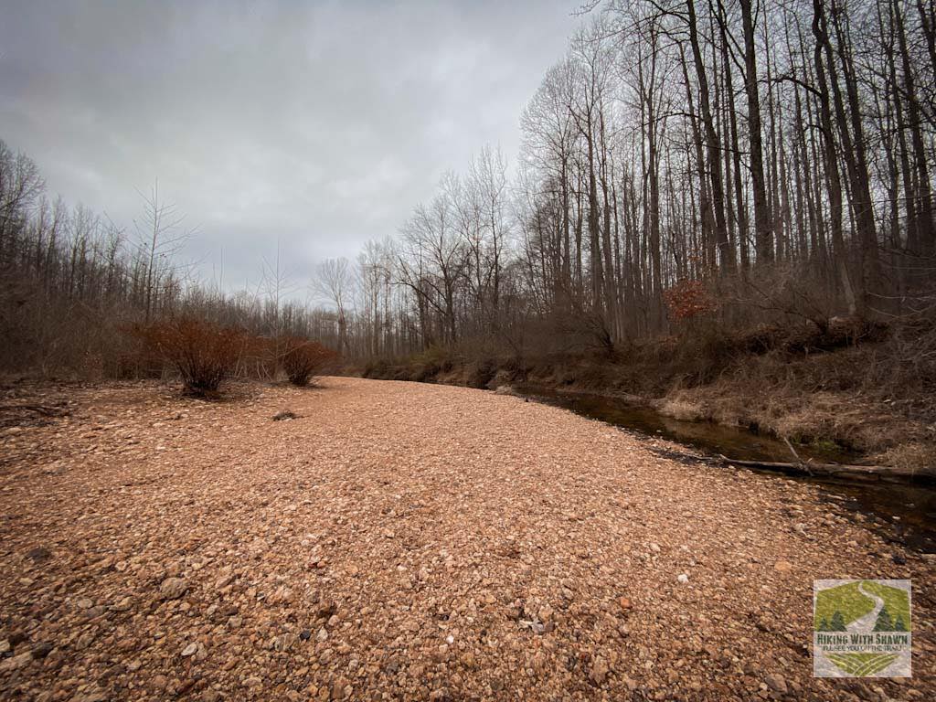
Typical Rock Bar in Hutchins Creek
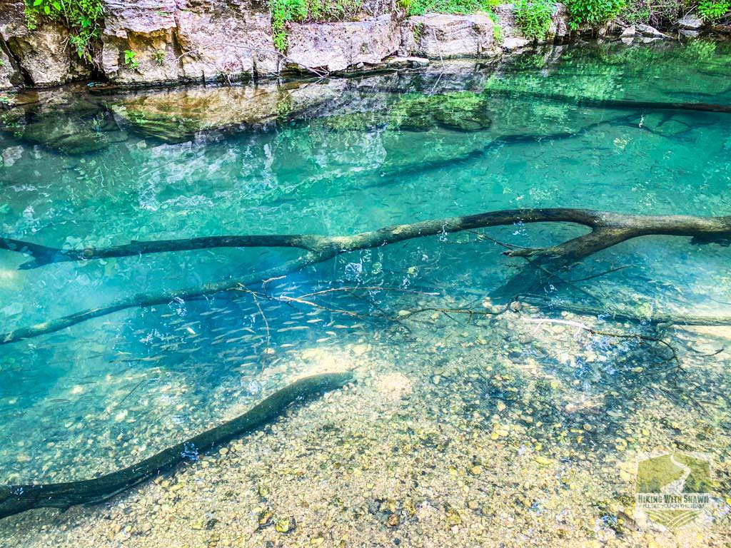
Spring-Fed Creek Water with Fish
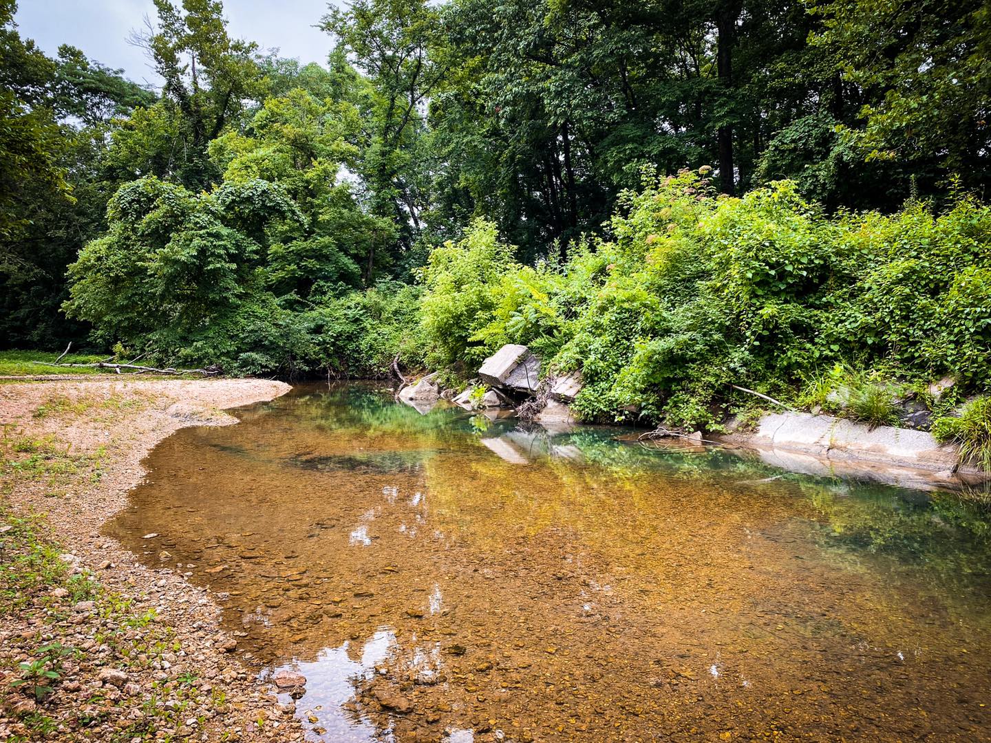
A Wading Area in Hutchins Creek
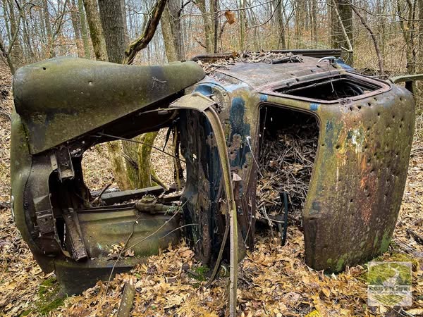
Remnant of the Odie and Florence Bridgeman Farm
Please Support Hiking with Shawn
Alrighty folks, I hope you have enjoyed this content. I provide it for free and it takes a while to create. If you would be so kind enough to support my efforts, you can do so by sharing this post with others, especially on social media. Be sure to subscribe to my YouTube Channel to see my latest videos, shorts and live streams. Follow me on Facebook, Instagram, and Twitter for unique content that you will only find on those pages. You might also join my Southern Illinois Hiking & Outdoor Resources Group on Facebook, too!
You can also support me by becoming a Patreon Supporter for as little as $3/month and you can cancel anytime (no contracts or catches). Patreons get access to extra features, exclusive articles, sticker packs, gifts and more. Consider buying official Hiking with Shawn Merchandise as another way to support me. I spend a lot of money on Hiking with Shawn and because of extremely high public land permit fees, I make very little money in return so everything helps.
Thanks again for checking out another one of my articles and until next time, I’ll see you on the trail!

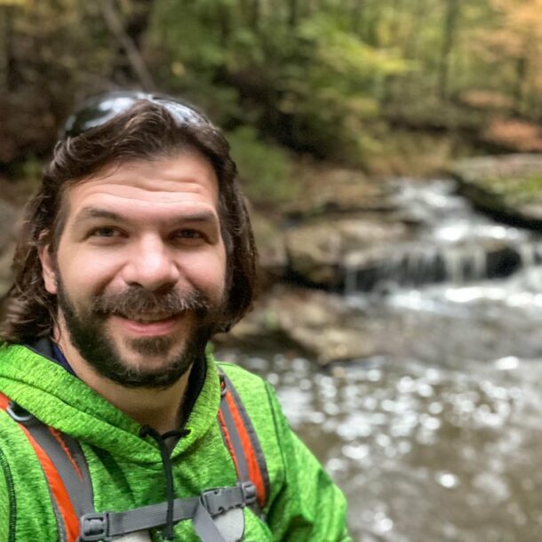
Shawn Gossman
Founder, Hiking with Shawn
Howdy folks! My name is Shawn Gossman and I founded Hiking with Shawn. I’m an avid hiker, cyclist and outdoorsman here in the Shawnee National Forest. I was born and raised in Southern Illinois and never want to leave. Click here to learn more about Shawn Gossman