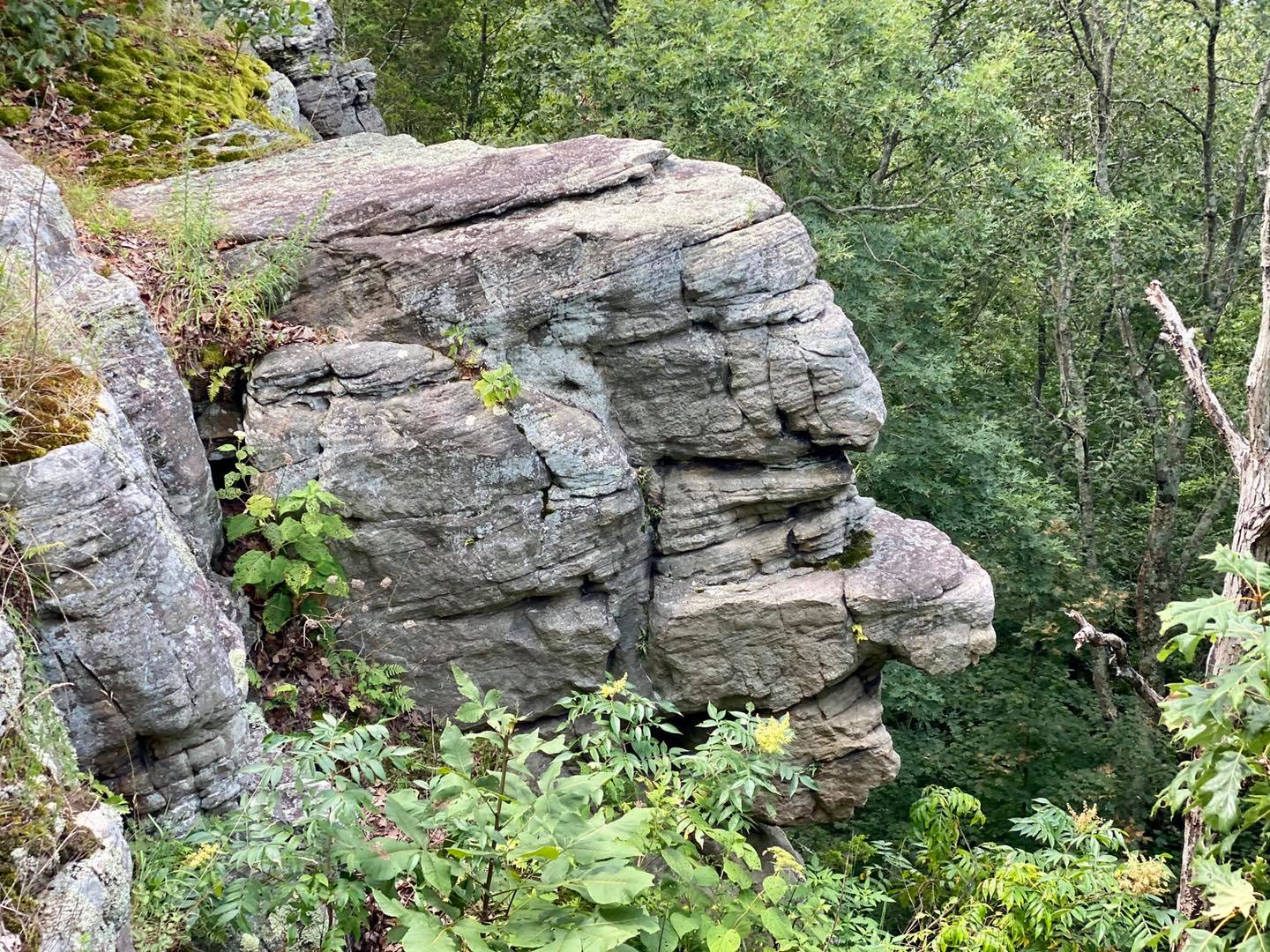
Old Stoneface
Trail Guide
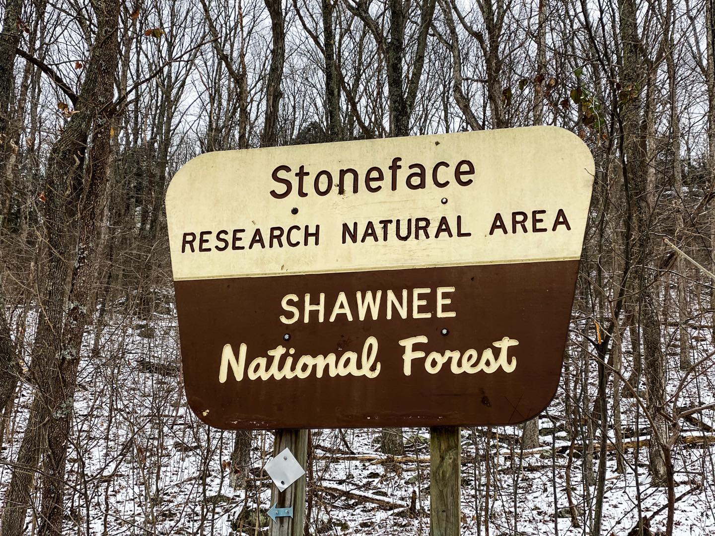
Shawnee National Forest
Old Stoneface is a 1.6-mile out and back moderately rugged trail in Saline County, Illinois. Old Stoneface trail features various bluff, rock formations and scenic overlooks. The trail is most known for its main rock formation called ‘Old Stoneface’ which resembles the face of an old woman (some say a man) that is along the upper portion of the trail. Old Stoneface is within the Stoneface Research Natural Area of the Shawnee National Forest. The area is a Natural Area due to precious botanical elements that have been found in the area including federal threatened Mead’s milkweed (Asclepias meadii) and two rare species: Chokeberry (Aronia melanocarpa) and Stonecrop (Sedum telephiodes) according to the US Forest Service.
While there is a parking lot to this area, there are no officially designated trails. The 1.6-mile trail listed above is completely user made. This means that there are no maps of the trail officially and it will not be maintained officially. A good and updated map for the Old Stoneface Trail is available for free on All Trails which originally was wrong but has since been changed to the correct trail (Thank you, All Trails). The culvert that was washed out a few years ago has been replaced and the road and parking lot has been fixed. There are enough parking spaces for about 5 or 6 vehicles. This is a hiking only area – equestrians, motor vehicles and bicycles are not allowed in Natural Areas. Foot travel is welcome. There are no rest rooms at the trailhead or any signage with area information aside from the Natural Area sign.
Please use caution in this area. There are various dangerous conditions existing here including high cliffs, venomous snakes, and trip hazards. This area is managed by the US Forest Service – Hidden Springs Ranger District.
Old Stoneface Trail Directions and Hiking Information
See this map for points of interest for the Old Stoneface Trail area.
From Harrisburg, Illinois when traveling by car – from the Intersection of N Main Street and Highway 13, go south on N Main Street for 0.3-miles and turn left on East Poplar Street. Drive 0.4-miles and turn left on Highway 45. Drive 0.8-miles and turn left onto Highway 145. Drive 6-miles and turn left onto Highway 34 just after Mitchellsville Country Store. Drive 2.7-miles and turn left onto Deneal Road. Drive until the road turned into Stoneface Road and follow it for 2 to 3-miles until you reach Stoneface Lane to your right. Turn right and drive up the hill to the parking area at the end of the road. This lane is gravel with some potholes present. It is not treated or plowed during wintry weather conditions and the hill will make the drive dangerous when slick.
The trail starts on the east side of the parking area loop. Within 20 or so feet into the trail, you will see the Stoneface Natural Area sign. It looks like a loop trail at this point. It is NOT a loop trail. The left trail is what you want to take to get to Old Stoneface as well as the large scenic overlook. The right trail can take you to the bottom of Old Stoneface and the base of the bluff.
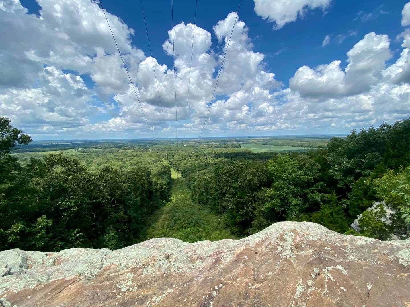
Take the left trail at the sign and head for 1.6-miles until you see the Old Stoneface (pictured below) on your right. The bluff will have an angle to it like stairs going down before it drops off. The area is right after the old fencing to your right. After that, you can continue ahead for about an eighth of a mile to the giant scenic overlook which is essentially a power line right-of-way. The trail continues after that and eventually goes down but gets sketchy and fades off in many spots. Please note that you may also get into private property continuing the trail past the scenic overlook, so it is a good idea to have a property boundary app like OnXHunt (not sponsored) or something like that. If you take the old jeep road up the power line right-of-way, it will take you to the top of Eagle Mountain.
Old Stoneface Trail Points of Interest Information
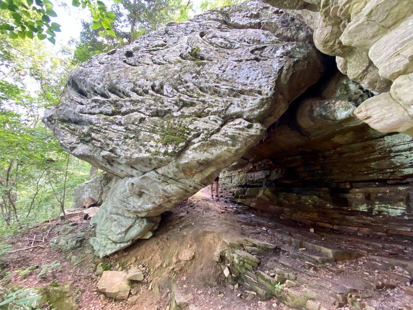
The lower portion of the 1.6-mile trail is very fascinating. You will reach an interesting bluff line with many different sights to see. There is a nice ledge that looks like a mountain lion would be waiting on and some of the locals might say that they have seen them there. Please check out my Bear, Mountain Lions and Wolves Guide for more information. There is also what appears to be an old mine that now looks like a natural cave shelter. You can tell it was dug into but I’m unsure of what kind of mine was once there. There is also a cool rock up against the bluff that you pass through. A nice rockslide will also provide access up or down if you don’t wish to finish the switchback. In the winter, while very dangerous, this area looks magical with all the icicles hanging everywhere. Just please be careful and always put safety first.
Once you reach the upper portion of the trail, the fun begins. There are a few overlooks to see the canopy of the forest from the start, but it is best to see that in the late fall and winter when the leaves are off. Then you will reach Old Stoneface which is the main feature of the entire area. There are plenty of side shots you can get with a camera. Braver people like to stand on the head of the rock formation. If you do, please be careful as a fall from that height will likely kill you. The rock is slick with when or covered in wintry precipitation so use caution if you visit in those conditions.
After Old Stoneface, you can walk to the main scenic overlook with a few smaller overlooks in between. The main overlook is a power line right-of-way. It is still a very beautiful overlook where you can see a lot of the Shawnee National Forest and southern Illinois countryside. It is pretty high up from the top so please put safety first as falling would likely result in death. If you take the jeep road up along the power lines, it will eventually take you to Eagle Mountain area. Sadly, some of the off-road community has really tore up the trails and trashed the area. It is one of the worst places I’ve ever seen for litter. It is really sad that people are that inconsiderate of public land.
If you go past the overlook, the trail will eventually take you down the bluff. The trail vanishes quite a bit after that. It doesn’t loop back to the parking lot like it may seem, though. There is private property out that way as well. If you decide to venture that way, I strongly suggest using a map or application to show you boundary lines of public verses private property. Please don’t trespass!
If you follow the creek (westward) where the new culvert was put in at the beginning of the Stoneface Lane for about a quarter of a mile, it will take you to an area of the creek with a very nice waterfall, big boulders and a shelter area. There are modern-day “rock art” paintings here. No one really knows where they come from, but it has been confirmed that they are not from ancient Native Americans. They call this particular area Ancestors of the Blood Grotto. Iron gets into the water and forms a blood-like coloration. While defiantly a faked rock art site, it is still very scenic and beautiful to visit.
A little past the creek into the forest (eastward) is a cemetery. The cemetery is pretty old with about 8 to 10 gravestones. The property around it is private and well-marked with No Trespassing signs and purple paint. As I have said before, please respect private property and do not trespass.
Old Stoneface Trail Safety and Important Information
Dangerous conditions exist in this area including high bluffs, slick rocks, and steep trails. This trail is moderately rugged and isn’t for very beginner hikers. There are some hills, loose rocks, slippery surfaces, and narrow portions of the trail. Please use caution and always put safety before all else when hiking in this area.
In the past, falls in this area has led to significant injuries to even death. One of the main hazards at this location is getting lost. This is not a loop trail. Stay on the main trail to avoid getting lost. Look for the arrow blazes (blue) when getting into switchback turns.
Cell phone reception in this area if often non-existent. Help from emergency service (Equality Fire Department) might take hours before arrival because of the remoteness and inability to reach anyone due to lack of cellphone signal. First responders are volunteer but very committed to their jobs. However, doing dangerous acts puts first responders at a safety risk when attempting to rescue you, please keep their safety in mind before performing a dangerous act.
Venomous snakes occur in this part of the region including copperhead and timber rattlesnakes. It is illegal to harass, harvest, harm or kill a snake on National Forest land.
Poison ivy occurs here. Mosquitos and ticks occur here and are responsible annually for transmitting harmful diseases onto humans such as West Nile, Rocky Mountain Spotted Fever, Lyme and Alpha-Gal. Please use appropriate DEET-based and other chemicals or natural solutions to repel these biting insects.
There is no trash service at this area. Please pack out what you pack in and always follow the principles of Leave No Trace.
Remember to Recreate Responsibly when visiting this area to help keep your fellow outdoor recreationalist safe.
This area is extremely hazardous during high water, snow, and ice events. Severe weather such as dangerous lightning, wind and even tornadoes can occur in this part of the region. Extreme hot and cold temperatures have been recorded in this area during summer and winter seasons.
The closest hospital to Old Stoneface is located in Harrisburg, Illinois.
Old Stoneface Trail Area Places to Eat, Sleep and Shop
For other outdoor recreational activities in this area, check out Garden of the Gods and Rim Rock for hiking opportunities. Garden of the Gods Wilderness and High Knob provide excellent areas for dispersed camping, backpacking and horseback riding activities. You can bike, kayak/canoe and fish at Glen O Jones Lake and cycling is also available in Harrisburg at Tunnel Hill State Trail.
For good eating, check out Mackie’s Pizza of Harrisburg for some of the best pizza around. The Gap bar and grill is another good stop. Mitchellsville County Store has excellent breakfast, lunch and dinner and is known for their fish. The Red Onion is Equality is a local favorite. The City of Harrisburg is full of different local mom and pop establishments to choose from as well.
For lodging in the area, try Pharaoh Campground for tent camping. Pounds Hollow Campground has tent and electrical sites as well as a beach (free for now) for swimming. High Knob Campground and Double M Campground is the local favorites for equestrian camping. For cabins camping, we recommend Rim Rock’s Dogwood Cabins which is pet friendly. There is also Timber Ridge Treehouses and Shawnee Forest Cabins as well.
For shopping, we defiantly recommend heading to Garden of the Gods Outpost for hiking and camping gear, general store items, Bigfoot stuff and some of the best ice cream around! The City of Harrisburg provides even more shopping opportunities with many businesses to choose from.
Watch the videos for the Old Stoneface trail!
Below is a recent video that we filmed while enjoying this area.
Check out the Old Stoneface trail gallery!
Enjoy these photos taken around this area!
Stoneface Sign
Balancing Rock
Old Stoneface
Stoneface Overlook
One last thing!
Filming the videos, taking the photos, editing everything and writing this article takes time and it’s all provided for free. Consider making a small monthly contribution to Hiking with Shawn by becoming an official Patreon supporter on Hiking with Shawn! You can also support us by purchasing official merch from the Hiking with Shawn online store. Lastly, please share this article and our videos and follow us on YouTube, Facebook, Twitter, Instagram and Tumbler for more free guides, videos, photos, contests and more!
Thanks for checking out this guide and please share it with others if you’d like to see more of them made!

Shawn J. Gossman
Host
Shawn is the founder and host of the YouTube Channel, Hiking with Shawn as well as Hiking with Shawn LLC. Shawn hikes, backpacks and visits various forested areas in the Shawnee National Forest, local state parks and other areas promoting outdoor recreational activities to obtain video to show to locals and non-locals alike. Please support Shawn’s efforts by sharing this post and leaving a comment below.